Protected Area
- Park Authority: Regional Office of Environment, Water, and Forests of the Waterfalls
- Headquarters: Banforà
- Tel: 00226.20.91.00.07
- Fax: 000226.20.91.06.68
- E-mail: doulkoma@yahoo.fr
- Area: 284,250 Ha (15% of the surface)
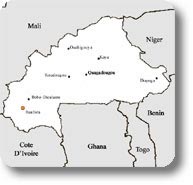
- Provinces: Comoé and Léraba
- Established in: not available data
The Waterfalls Region
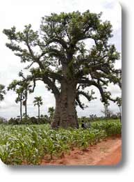
The population (in 1993) has been assessed in 352,637 inhabitants; the 90% of the regional area is used for agricultural purposes. Agriculture, breeding, craftsmanship, and fishing are the main sources of subsistence and income for the population. The climate is Sudanese-like with annual rainfall varying from 800 to 1,200 mm.
From an economic point of view, the region is marked by the presence of several transformation industries like SN. SO SU SO, GMB, SOPAL, les Scieries (the Sawmills), etc.
The Territory of the Reserve
There are also several natural lakes and dams. These watercourses represent important sites of production deriving from fishing. The fishing production is of about 200 t/year.
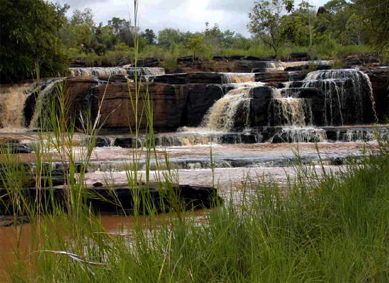
As far as tourism is concerned, the region is rich in great tourist potentialities, among which the Peaks of Sindou, the hippos' lake of Tengréla, the domes of Fabédougou, the troglodyte village of Néguéni, the characteristic fauna of the forest areas, the waterfalls of Karfiguela, Tourny, etc. Moreover, there is an abundance of handicrafts and a rich folklore. However, the sector is experiencing many difficulties linked to the lack of planning of the tourist sites, the lack of information and advertisement on the tourist sites, to the weak welcome capacity of the hotels and the weak interest of the private economic operators in the field.
The Threat of Desertification
As a matter of fact, the vegetal formations mainly consisting of arboreal savannah, forests, and forest corridors are fragile and have experienced in recent years an accelerated rhythm of deforestation caused by the important migration waves coming from the most populated and driest regions of the north and by the return of the natives from the coastal villages.
Transhumance, extensive cultivation methods on burnbeaten lands, the uncontrolled fires in the savannah and the "anarchic" cutting of the wood must be added to the above-mentioned causes. Given the density of the herbaceous covering, the fires of the savannah interest every year most of the region (about the 85% of the area burns every year).
Late fires (February-April) cause more damages.
Moreover, it is a rather flat region with an average altitude of 300 m dominated in the north-west by a sandstone cliff of a height of about 100 m.
The soils of the region are rather sandy, marshy, and often poor. Here and there you can see the laterite soils left exposed by the superficial erosion. Along the valleys you can see deep alluvial soils, clayey or muddy, or regions with hydro-agricultural structures.
The sustainable exploitation of these resources needs above all a better knowledge of their state (potentiality and evolution), of the economic and social importance, of the identification and promotion of the different enhancement possibilities (craftsmanship, ecotourism, local products); therefore, in order to meet this imperative of management, there is on the program the creation of an ecomuseum in Banfora, whose objectives are the following:
- working as a place to promote environmental education and the knowledge of the tourist and craftsmanship potentialities of the regions and of the waterfalls in general, as well as of protected forests, in particular of the wildlife reserve of Comoé-Léraba;
- improving the communication of information regarding biodiversity;
- improving the awareness and understanding of the issues regarding the conservation of biodiversity within the population, the technicians, and decision-making people;
- providing everyone with the possibility to acquire information, knowledge, and competence, as well as the will to protect and improve our environment towards a sustainable development.
The Regional Office of Environment, Water, and Forests
D.R.E.E.F has been entrusted by the Department of the Environment to accomplish its policy in the two provinces of the south-west of the Country. For this reason, its mission consists of the following actions:
- supporting the population in rural development activities
- giving an essential contribution to the conservation of the natural resources and the safeguard of the environment
- promoting the development of consultation among the structures supporting the regional agricultural world.
Within its missions, D.R.E.E.F acts in five essential directions:
- the forestation of the village, that is the group of activities touching the tree, directly or indirectly, and its setting in the rural environment, considering all its possible uses and the interactions linking it to the other components of the environment. The sphere of influence is the village;
- the planning of natural formations (wildlife reserves, hunting areas, state forests, areas of forest exploitation);
- the enhancement of resources like fishing, lake and pond management for fish production;
- the conservation of the environment through the struggle against pollution and the improvement of the quality of life;
- the application of the laws on the environment.
Besides these activities, D.R.E.E.F also deals with the training of the agents and of the producers, the adaptation of legislative texts, the control-evaluation of the research activity.